Disclaimer: All discussions, forecasts, and opinions on this website are mine alone, unless stated otherwise, and should not be use in severe weather decisions. Consult with the National Weather Service and Storm Prediction Center for up-to-date severe weather information: NWS Website and SPC Website
If you have any questions or comments you can send emails to the website's email account:
joshua.l.schank@schankweatherstationmo.oucreate.com
Severe Weather Discussion for Next Week *Check for Updates*
Severe Weather Forecast
Issued 1200 PM CDT Wednesday May 02, 2018
Valid Wednesday May 02, 2018 - Thursday May 03, 2018
...Discussion...
There is a chance of severe weather for Wednesday and Thursday this week. A
changing synoptic-scale pattern shows a large-scale trough developing over
the western portion of the United States. This will help cause winds over the
Gulf of Mexico and the southern Plains to veer southerly and transport warm
moist air northward from the Gulf to the Plains. The moisturing of the
boundary layer and the possible advection of desent lapse rates will lead to
unstable air over the central plains.
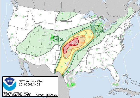
On Wednesday/D1 storms will probably be more wide spread as the trough moves
eastward closer to the Plains compared to Tuesday. Low-level moisture will be
well established as winds continue to be southernly over the Gulf and
southern Plains. A surface low will be developing around the Colorado and
Kansas border with the stationary front stretching from northern Kanasas or
southern Nebraska and Iowa. The dryline has mixed further east and is now in
east-central Kansas and down into central Texas. The risk of severe weather
is greatest in central and NE Kansas into NW Missouri and down into Oklahoma
near the panhandle. Steep mid-level lapse rates with large amount of CAPE
and instablility will lead to a high chance of hail and severe winds. Tornado
risk is hard to determine because hodograph/shear is not that impressive in
the observe and forecast soundings at the moment especially in NE KS and NW
MO. However, the tornado threat is still present.
...Schank 05/02/2018...
|
Here are the Convective Outlooks for Wednesday (May 2) from the SPC