Disclaimer: All discussions, forecasts, and opinions on this website are mine alone, unless stated otherwise, and should not be use in severe weather decisions. Consult with the National Weather Service and Storm Prediction Center for up-to-date severe weather information: NWS Website and SPC Website
If you have any questions or comments you can send emails to the website's email account:
joshua.l.schank@schankweatherstationmo.oucreate.com
Severe Weather Discussion for Next Week *Check for Updates*
Severe Weather Forecast
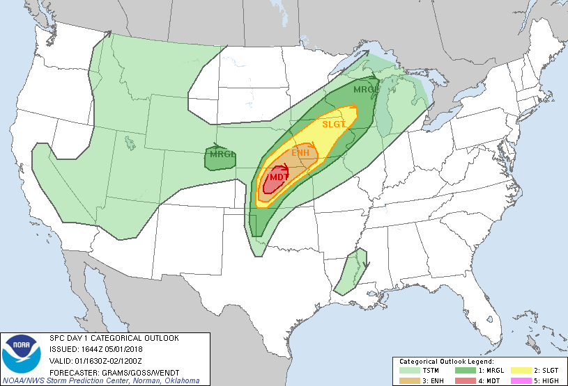
Issued 1215 PM CDT Tuesday May 01, 2018
Valid Tuesday May 01, 2018 - Wednesday May 02, 2018
...Update 05/01/2018...
The highest risk on Tuesday appears to be confined to central KS, SE NE, SW
IA, and extreme portion of NW MO due to the hindering of convection from
capping which increase as you move away from the boundaries like the dryline
or cold front. The location of those boundaries is discussed in the below in
the discussion for Tuesday. Hail will be the biggest threat as forecast
soundings show 2500 - 3000 J/kg of CAPE and steep lapse-rates. The HRRR at
15 Z runs is showing storm development along the dryline near the OK/KS
border and forecast soundings do show hodographs favorable for rotation in
the envirnment. However, with high LCLs the tornado risk is diminished.
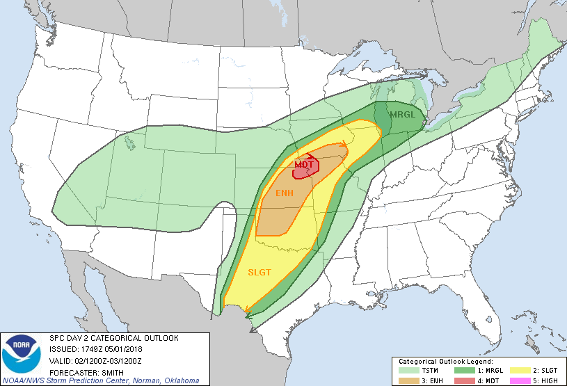
...Update 04/30/2018...
The risk of severe weather for Wednesday/D3 has been trending to shift a
little toward the east in the model runs. A stationary front will be
position across NE Kansas and SW Iowa and will help initiate storms.
However, models are disagreeing with environment over NW MO since outflow
from storms in Kansas will affect the stationary front, so how widespread
and type of severe weather NW MO could experience is still up in the air.
Right now the tornado risk looks to be low and strong straight-line winds,
hail, and heavy rain will be the main threat.
...Update 04/28/2018...
The Discussions below for the most part are still valid, but the models are
causing slight shifts in where storms may develop and where the highest risk
of severe weather will be. This is to be expected and this will continue
until storms develop on those days. Keep checking the updated forecast to
stay inform of changing weather conditions in the next few days.
...Discussion...
There is a chance of severe weather on day 1 and 2 according to models. A
changing synoptic-scale pattern shows a large-scale trough developing over
the western portion of the United States. This will help cause winds over the
Gulf of Mexico and the southern Plains to veer southerly and transport warm
moist air northward from the Gulf to the Plains. The moisturing of the
boundary layer and the possible advection of desent lapse rates will lead to
unstable air over the central plains.
On Tuesday/D1 the most likly area of storm intiation will be northeast of the
triple point, located near the KS/OK boarder, in north-central Kansas and SE
Nebraska along the cold front, but storms will probably be more linear in
nature with more discrete cells forming in southern Kansas, Oklahoma, and
Texas Panhandle where the dryline will be located just south of the triple
point. The tornado threat will be the highest where storms remain discrete
and form in strong shear enviromnents. NW Missouri looks to be the only part
of the state to have a chance of severe weather at the moment, and the main
threat will probably be strong winds, heavy rain, and maybe some hail if
strong/severe storms move into the area.
On Wednesday/D2 storms will probably be more wide spread as the trough moves
eastward closer to the Plains compared to Tuesday. Low-level moisture will be
well established as winds continue to be southernly over the Gulf and
southern Plains. A surface low will be developing around the Colorado and
Kansas border with the stationary front stretching from northern Kanasas or
southern Nebraska to Michigan. The dryline will stay quasi-stationary in
western Kansas and down into central Texas. The risk of severe weather is
greatest in Kansas east of the dryline along with a portion of eastern and
northern parts of Oklahoma. Small portins of SE Nebraska, SW Iowa, NW
Missouri, and north-central Texas also have a risk of severe weather due to
all areas at risk showing favorable enviroments with low-level wind shear,
low-level moisture, and instablility to support rotation/supercell
development. However, as you move away from the dryline the convective
(storm) modes will probably get more complex as storms become less discrete
and become clustered or go linear as they form. So they main threat of
tornadoes and hail will be near the dryline with damaging winds, flooding,
and some hail being the biggest threat as you travel further from dryline.
...Schank 05/01/2018...
|
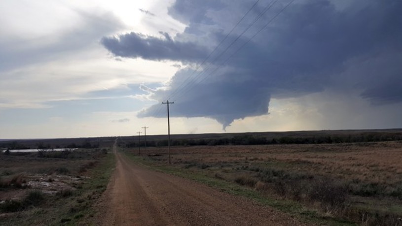
Here is a picture of a supercell that I took on May 01, 2018 near Buffalo, OK
Here are the Convective Outlooks for Tuesday (May 1) and Wednesday (May 2) from the SPC