I will try to update this page when severe weather threatens Missouri. I will especially focus on areas like Kansas City, MO and northward along with the area around Springfield, MO which includes Branson, MO. In my discussions any updates are listed from new to old, so keep that in mind when reading my discussion down below.
Disclaimer: All discussions and forecasts on this website are mine alone and should not be use in severe weather decisions. Consult with the National Weather Service and Storm Prediction Center for up-to-date severe weather information:
NWS Website
and SPC Website
Personal Day 1 Severe Weather Outlook
0600 PM CDT Fri April 13, 2018
Valid Apr 13 2018 0615 PM - April 14 2018 0600 AM
...UPDATE...
The main threat for The NW Missouri especially near Kansas City, MO will be
strong winds and possible hail. Storms in SW Missouri are now more
widespread and main threat is south of Springfield and Branson. The risk of
tornadoes is decreasing with time for all areas mentioned above, and if
there no new developments then this will probably be the last update.
...NEW WATCHES...
A few minutes after my last update, the SPC issued that tornado watch for
NE Kansas, SE Nebraska, NW Missouri, and Southern Iowa.
...WATCHES ARE BEING ISSUED...
Tornado watches have been issued for eastern Oklahoma, SW Missouri,
NE Texas, and most of Arkansas. The SPC is also discussing the possiblilty
of creating a watch for NE Kansas and NW Missouri.
...UPDATE...
The models are now putting the dryline a little further west compared to
yesterday. This could push back the timing of storm iniation for the main
system in Missouri from 3-4 pm to 5 pm or later in the evening to night
hours. The main tornado threat appears to be in Arkansas where storms
will be more wide spread. As you travel north into Missouri and up into Iowa
storms will be more isolated in nature due to an increase in cloud cover in
the forecast and strong capping during the day, so not everyone will see a
storm. The environment in those areas are not as impressive but some wind
shear is still present in the forecast sounding hodographs, so supercells
and tornadoes cannot be ruled out.
...NOTE/UPDATE...
Models for southwest MO near Springfield and Branson still show enviroment
conductive of supercell development just like in NW MO, but models are
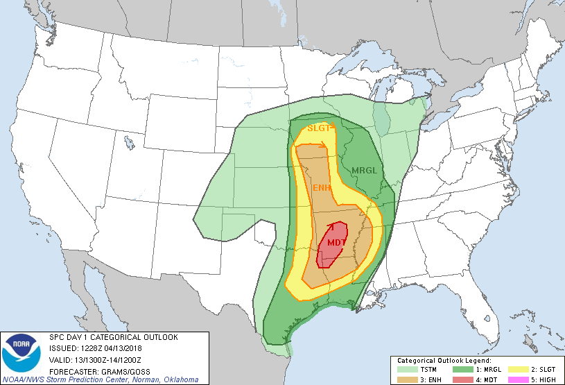
struggling to produce storms in future radar projections. Reading the SPC
Outlook, that was updated at 11:30 AM, explains that they will keep the
ENHANCED RISK as shown in the grapic above for now, but their confidence for
where storms will develop in the region is lowering. I still believe at
least a couple of storms will develop and I hope everyone in the area will
stay weather aware incase severe storms develop. Remember, storms will not
be widespread in nature through out Missouri, so it will be hit or miss if
storms will hit your location.
...Schank...04/13/2018
...Discussion from April 12, 2018...
...SUMMARY...
Strong/Severe storms are expected to form Friday in the afternoon and
continue into the evening and night hours. The main threat seems to be
located from southern Iowa to east Texas and northern Louisiana. All types
of severe weather are possible with hail and a few tornadoes, a couple of
them could be strong, as the main threat.
...Synopsis...
The upper level trough will move over the Great Plains on Friday and deepen
as it moves past the Rocky Mountains. Along with shortwaves within the
trough, will aide in large scale lift over the area with the risk of severe
weather.
Models place the surface low in Nebraska on Friday as it move eastward
during the day. The warm front in the late afternoon looks to be located
across Iowa as it slowly moves northward, with the cold front extending from
the low pressure system thru Central Kansas and Western Oklahoma as it moves
in eastern/southeastern direction. The dryline will mix eastward and will
be along the Nebraska/Iowa, Kansas/Missouri, and Oklahoma/Arkansas boarder
by late afternoon. Storms are likely to initiate along the dryline.
Depending on Mean Wind Direction during the intiation will help determine if
storm cells remain discrete or become linear after forming.
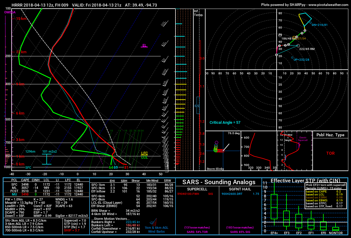
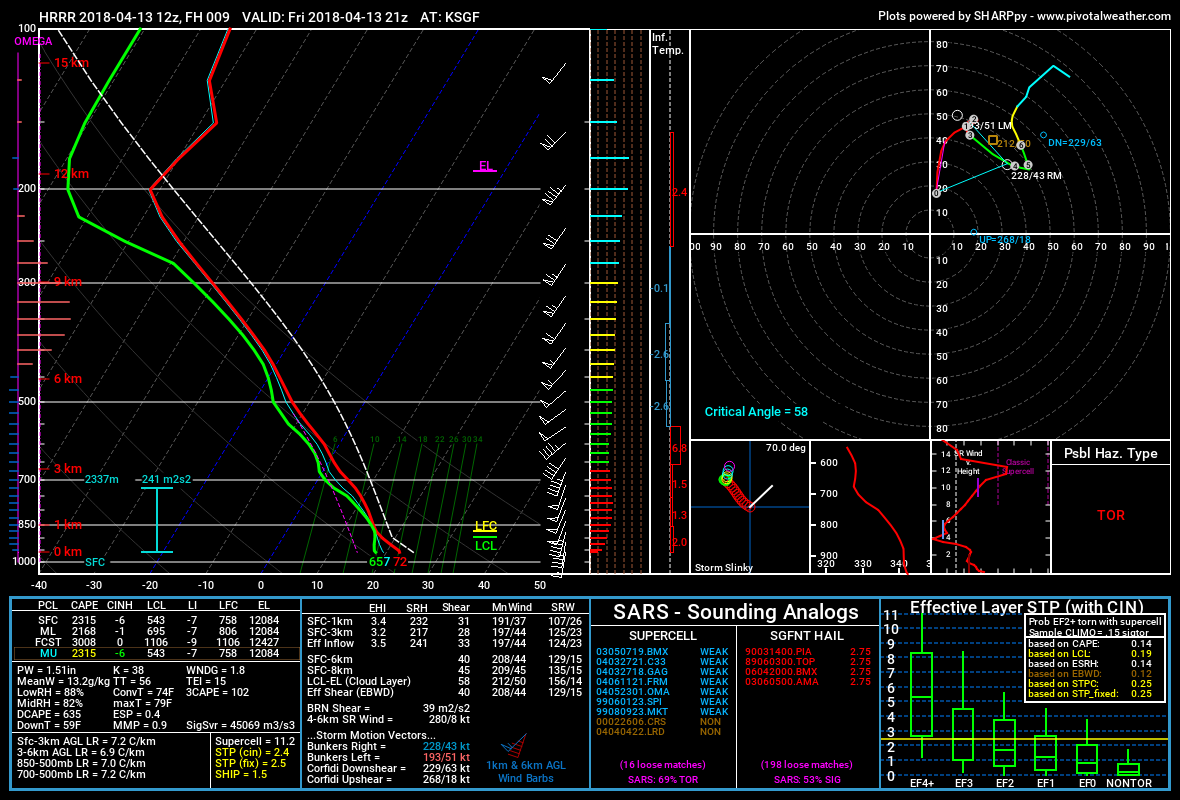
...Northwestern Missouri to southwestern/central Missouri...
Forcing/lift for storm development will most likely happen first in
northwest MO in the afternoon after 4 pm, with forcing/lift happening in
southwest/central MO in the evening or night hours as the dryline mixes
eastward with time. mix-layer CAPE in Norhwestern MO will be likly be 1500
-2000 J/kg and up to 2500 J/kg in southwest/central central Missouri where
storms will probably be more widespread.
If storms can remain discrete after formation or while moving into the area
then the enviroment will likely support strong/rotation updrafts which will
give rise to supercell thunderstorms, with large hail and a tornado threat
expected, especially in northern MO. Remember, if storms are discrete then
storms will be more isolated in nature and not everyone will see a storm. If
the event is more widespread and linear then the risk of tornadoes will
decrease and straight-line winds will be the main threat.
...Schank 04/12/2018...
|